Donate
USA for UNHCR Launches Satellite Imagery and Crowdsourcing Project to Improve Refugee Camp Planning and Maintenance
Machine-learning algorithms will transform current methods of mapping UNHCR refugee camps around the world.
USA for UNHCR, the UN Refugee Agency, announced a campaign to improve shelter and protection for refugees living in camps around the world by harnessing the power of satellite imagery and machine learning. The project will use high-resolution satellite imagery from DigitalGlobe, a Maxar company, and its crowdsourcing platform, called Tomnod, to tag key structures in refugee camps, such as tents and permanent structures, to improve UNHCR’s site planning and field operations. The dataset will be used by Stanford University’s Sustainability and Artificial Intelligence Lab to generate a training dataset to develop a machine learning algorithm to recognize and count the structures.
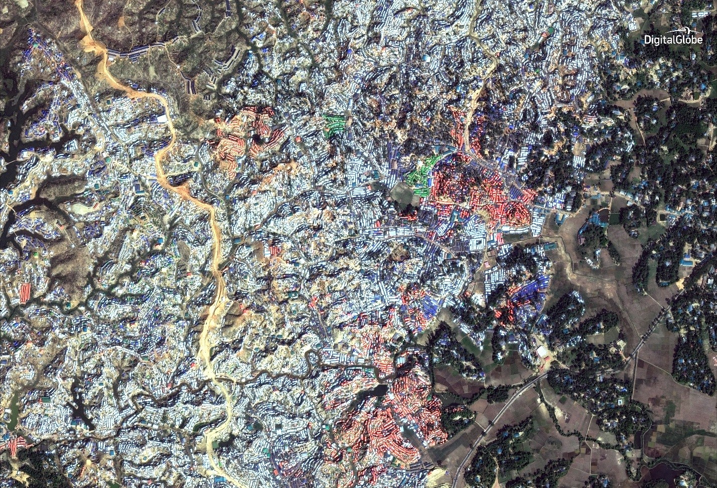
The above satellite image shows the Kutapalong Refugee Camp in Bangladesh on Dec. 29, 2017. Satellite imagery © 2018 DigitalGlobe
“The outcomes from this work will be very tangible and have the potential to make a direct impact on the lives of refugees,” said Rita Ko, Director of the Hive, USA for UNHCR’s innovation lab. “This approach will help UNHCR map refugee camps at a greater speed and with improved accuracy to deliver lifesaving aid more effectively and efficiently.”
The rapidly increasing number of forcibly displaced people around the globe – estimated at 65.6 million – has led to the construction of new refugee camps and the expansion of existing ones. With this comes a need to ensure camps are being built and maintained efficiently and sustainably when it comes to the location of shelters, water sources and other variables. Camp mapping is essential but labor intensive as field staff typically survey the camps on the ground and upload the data manually.
The mapping project is expected to reduce the amount of labor and staff time needed in this process dramatically by:
- Providing the highest resolution satellite imagery commercially available to be used in field operations and training, such as implementing decongestion interventions to ensure better access for emergency services and pinpointing gaps in provisions for latrines, water points
and waste collection. - Developing and training machine learning algorithms that detect changes in refugee camps, such as road construction/obstruction and deforestation.
The first phase of the project will engage volunteers through "#WithRefugees: A Look at the Refugee Crisis from Above”a campaign on DigitalGlobe’s Tomnod crowdsourcing platform asking the public to identify and tag four types of shelters (tents, improvised, semi-permanent and administrative shelters) in satellite imagery. When the campaign is complete, USA for UNHCR will receive shapefiles containing the tagged information.
“Tomnod and the crowd who volunteers their time on the platform are enabling DigitalGlobe to transform satellite imagery into meaningful datasets and actionable insights to help save lives, resources and time,” said Jeremy Hale, DigitalGlobe’s Global Development Manager. “By partnering with
In the second phase of the project, the tagged data will be used to create training imagery to feed to convolutional neural network models at Stanford University’s Sustainability and Artificial Intelligence Lab to automatically identify and count tent features from satellite imagery of other UNHCR refugee camps around the world. Modeled loosely on the human brain, the neural models can recognize patterns in images, sound
116 out of 202 UNHCR refugee camps will be mapped following the same shelter mapping methodology developed in recent years by UNHCR and the UN Institute for Training and Research - Operational Satellite Applications Programme, which has generously contributed to this effort by providing guidance on satellite imagery, mapping refugee shelters in different environments and broader machine learning efforts. Additionally, the Hive will share imagery data on OpenStreetMap and UN Humanitarian Data Exchange Portal, open source data platforms that are available to other UN agencies and international relief organizations.
Learn more at www.UNrefugees.org and on Twitter at @UNRefugeeAgency.
For additional questions, please contact:
Seema Iyer - seema@unrefugees.org
More Related News
Sudan Crisis Explained
Since the conflict in Sudan began in April 2023, more than 8.6 million people have been displaced, including more than 6.5 million people within Sudan and many more who have fled to neighboring countries.